International Research Experiences for Students (IRES)
The National Science Foundation (NSF) funded International Research Experiences for Students (IRES) Flood Resilience Program (FRP) between the U.S. and the Netherlands provides students with international research experiences under the guidance of faculty and researchers from multiple disciplines in both countries. Each year of the program, U.S. students engage in an immersive, six-week problem-and place-based research experience in the Netherlands, a world leader in flood risk mitigation and management. The primary goal of the program is to prepare the next generation of engineers and scientists that will have to tackle the societal problem of widespread flooding in an innovative fashion.
SPONSOR: National Science Foundation
PROGRAM DIRECTOR: Yoonjeong Lee
PI: Samuel Brody
CO-PIs: Jens Figlus, Yoonjeong Lee
Upcoming 2025 Program Details:
APPLICATION IS CLOSED
NSF IRES Flood Resilience Program – Integrated research experiences to foster understanding on how to increase resilience in flood-prone communities
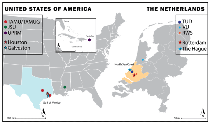
The National Science Foundation (NSF) funded International Research Experiences for Students (IRES) Flood Resilience Program (FRP) is pleased to offer funding for students at participating universities – Texas A&M University (Galveston and College Station campuses, TAMUG/TAMU), Jackson State University (JSU), and the University of Puerto Rico at Mayagüez (UPRM) – to travel to the Netherlands from May 11 to June 21, 2025, to conduct in-depth research related to flood resilience*. The research travel involves field trips, lectures, and interactions with international experts and students in the Netherlands. Conducted through place-based case studies, participating students can either compare the Netherlands (the North Sea Coast and the Rotterdam-The Hague metropolitan area) with Texas (the Upper Texas Coast and Houston-Galveston metropolitan area) or investigate the applicability of flood mitigation measures from one place to another. This opportunity allows both undergraduate and graduate students to enhance and expand their educational and research experience through immersive research activities and interaction with international students and researchers in the Netherlands.
We encourage students from diverse disciplines – such as engineering, planning, economics, hydrology, biology, architecture, computational hydraulics, etc. – who are interested in flood resilience to apply. This program provides a unique opportunity to participate in interdisciplinary research with applicants from diverse backgrounds and academic levels, fostering teamwork and leadership skills development.
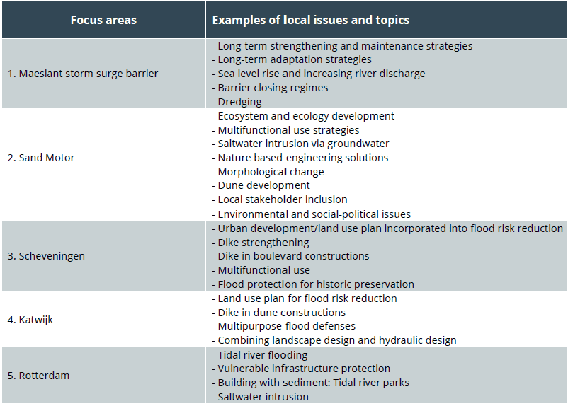
Applicants may choose one of the focus areas listed below for research in the North Sea Coast and Rotterdam-The Hague metropolitan area in the Netherlands. For these focus areas, research topics related to local issues and examples of research questions have been identified below. Applicants should submit a Letter of Intent (LOI) that aligns with their chosen focus area and suggested research topic of their choice. Alternatively, applicants can select any focus area within the North Sea Coast and Rotterdam-The Hague metropolitan area that is not listed here and develop their own research question or choose from the examples provided below.
*Important Notes:
- This funding opportunity is only available to U.S. citizens and permanent residents.
- Funding covers one round-trip flight, accommodations, and a weekly stipend of $600.00 for 6 weeks in the Netherlands. The schedule is non-negotiable, and funded participants will travel together.
- Funded participants are expected to publish a peer-reviewed journal paper based on the research conducted in the Netherlands after returning to the U.S., with guidance from the faculty mentors in this program.
- The program cannot accept research proposals that require access to experimental laboratories for chemical or biological experiments.
Please take the time to read the descriptions of the North Sea Coast and Rotterdam-The Hague metropolitan area thoroughly before completing your application.
2025 IRES FRP - Focus areas and research topics

IRES FRP collaborating institutions (circles), case study regions (stars) in the U.S. and the Netherlands: TUD – Delft University of Technology; VU – Vrije University; and RWS – Rijkswaterstaat
Application is now closed

Application is now closed.
North Sea Coast and the Rotterdam-The Hague Metropolitan Area
The Dutch North Sea coast consists mainly of straight sandy beaches and various large-scale tidal inlets. Most parts of the coast are protected by dunes, which shield the low-lying hinterland (often below sea level) from flooding. In areas where dunes are lacking, sea dikes and storm surge barriers provide coastal protection. These measures not only prioritize safety but also align with ecological, economic, and spatial planning ambitions whenever possible.
Dutch national flood risk management policies aim to address evolving future conditions through integrated and sustainable strategies. In 1990, the national government declared the imperative to maintain the coastline’s position as of 1990 throughout the next century through dynamic coastal management. This approach secures flood safety while supporting economic development in coastal areas.
One prominent project inspired by this vision is the Sand Motor, a mega beach nourishment consisting of 21 million cubic meters of sand. Installed in 2011, it is designed to protect the coast for over 20 years using Building with Nature principles. Additionally, it provides recreational areas, fosters new ecosystems, and creates economic opportunities. Other multifunctional flood defense projects along the coast include the dike-in-boulevard at Scheveningen, the garage-in-dune at Katwijk, and the dike-in-dune at Noordwijk. By integrating urban spatial planning into flood risk management, innovative and comprehensive solutions have emerged.
Changing physical and social conditions inspire new initiatives. Coastal cities like Scheveningen and Rotterdam face multiple challenges such as sea level rise, compound flooding, rapid urban development, and population growth. The Maeslant storm surge barrier in Rotterdam is confronted with rising water levels from both river and sea. Collaborative efforts among engineers, planners, ecologists, policymakers, and other experts explore solutions like constructing a string of barrier islands to protect the coast and redesigning the western part of the Netherlands for managed retreat.
- What are the major differences between Galveston and Scheveningen in flood resilient development strategies and what are the pros and cons implementing them?
- How does provision of flood protective infrastructure affect private-sector decisions to self-insure and self-protection?
- How have adaptive capacity, environmental, and institutional factors contributed to disaster resilience of coastal towns?
- How can coastal flood protection be designed for multifunctional purposes (e.g., add recreational, urban and/or ecological functions)?
- How do sediment deposition patterns and volumes differ between the Dutch North Sea Coast and the Texas Gulf of Mexico Coast?
- How do coastal flood resilience strategies incorporate sea level rise?
- How do pristine and engineered vegetated dunes differ between the Netherlands and the upper Texas coast; how are they being used in coastal protection schemes?
- (How) does Coastal Engineering with Nature in general and/or vegetated dunes specifically, differ between the Netherlands and Texas?
- How are Natural and Nature-Based Features (NNBF) in general and/or vegetated dunes specifically incorporated in coastal planning and management?
- How are NNBF and engineered dunes resilient to erosive forces, overtopping and overflow during severe storms?
- How can NNBF best be implemented in numerical modeling approaches intended to simulate coastal geomorphology changes?
- (How) Could a Sand Motor be implemented along the Texas coast?
- What flood protection alternatives are currently utilized in the Netherlands and how can they be defined, characterized, and visualized?
- How can multiple urban flood mitigation techniques work together to effectively reduce flood losses over time?
- What are the implications of coastal inlets for urban flood protection planning efforts?
- Can natural inlet fluctuations (spatial and temporal changes of location and level of opening) and commercial use of natural coastal inlets coexist? How do the Netherlands and Texas approach this issue?
- How is flood infrastructure financed and what are the main financial instruments used to finance both the new as well as upgrade existing projects?
- What tools are used to evaluate the viability of flood control projects and what are they based on?
- What adaptive strategies are adopted in flood-resilient coastal towns to cope with their growing population?
- How do the Netherlands and Texas differ in dredging and dredged material placement methods and practices?
- How do sediment deposition patterns and volumes differ between the Dutch North Sea Coast and the Texas Gulf of Mexico Coast?
- How do coastal flood resilience strategies incorporate sea level rise?

Questions about the program?
Please contact the IRES program director, Dr. Yoonjeong Lee: yoonlee@tamug.edu
Questions about the application?
Please email ires-frp@tamu.edu

