By Nicholas Diaz, PhD student, and Dr. Andrew Juan, Associate Research Scientist
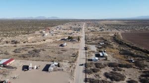
Arriving in Fort Hancock, Texas for the first time, it was clear to us that this community was in an entirely different flood situation than most of the communities we typically work with. Approximately 55 miles southeast from the rapidly developing city of El Paso, Texas and just off highway I-10, the Fort Hancock colonias experience frequent power outages and water supply shortages, especially during flash flood events. Many arroyos, or normally dry floodways, intersect the community heading south towards the Rio Grande River. During monsoon seasons–spanning the months of June to October–these arroyos can overflow causing people’s backyards and property to become rapidly moving flood zones.
 Unfortunately, most of the flood hotspots identified by local residents are not reflected in the outdated (1985) FEMA floodplain maps, thereby hindering efforts to support on-the-ground changes and flood regulations. Residents have consequently taken matters into their own hands to protect themselves, their families, and their residences by modifying the surrounding terrain with tires, tubes, and other materials to divert stormwater runoff away from their properties. However, depending on who has the elevational and upstream advantage, these modifications could unintentionally exacerbate impacts to nearby or downstream neighbors. After hearing countless stories, we understood that this community was navigating flood risk in the dark due to the lack of accurate and reliable data.
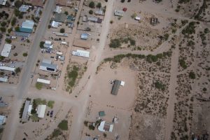
To address this data desert, we decided to employ an unmanned aerial system (UAS), or drone, to capture topographic and elevation data of the area. This geospatial data captured via drone has a higher resolution than available satellite data and can effectively capture current changes to the area. For comparison, the drone can capture data at centimeter-level horizontal and vertical accuracies while satellite data is at meter-level accuracies. High-resolution topography data is especially critical in reducing uncertainties underlying modeled floodplain extent and depth. Uncertainties exist within low-resolution topography data due to elevation and terrain changes that could happen at the smaller scale such as drainage ditches and curbs, or in this case, arroyos and landfill around structures.

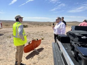
We returned to Fort Hancock in the summer of 2023 to execute drone operations and collect high-resolution imagery of Fort Hancock. The drone deployed was a WingtraOne Gen II by Wingtra which combines the benefits of vertical-take-off-and-landing (VTOL) and fixed wing capabilities that allows us to capture images of large areas efficiently. In other words, we captured all of Fort Hancock (about 2,000 acres) in just four hours. Approximately 3,700 overlapping hi-resolution images were captured with the goal of being able to photogrammetrically (stitch-together) map the community and create technical products such as digital terrain models (DTMs). DTMs provide a digital representation of the elevation profile of an area, including natural features like arroyos. DTMs can be used to help identify existing drainage features, potential flood drivers, and inundation hotspots within Fort Hancock

The drone dataset can also be coupled with local knowledge such as stories and mobile phone media of flooding captured by local residents who participated in other DRIP efforts led by Keri Stephens; Professor, Samanta Varela; Postdoctoral Researcher, and Yifan Xu; PhD Student. These efforts, known as the “Fort Hancock Community Flood Knowledge Collection Project,” focused on developing a process to collect community-held knowledge (such as photos; verbal descriptions of water lines and dates of major storms leading to flooding; and verbal identification of areas/locations prone to flooding, etc.) to inform future mapping and modeling products. The main product from these efforts will be a systematic collection of data focused on documenting and describing flooding in this flash-flood vulnerable community.
Leveraging drone technology to gather high-resolution topographic data allows us to create a more up-to-date topographic map of Fort Hancock which will provide the foundation for future flood risk insights. This data combined with floodplain modeling, and community input, puts the community ‘back-on-the-map’ in the sense of being heard and seen as a reflection of actual flood risks experienced by the locals.
In this endeavor, we extend our heartfelt gratitude to the dedicated representatives from Hudspeth County and Fort Hancock. Their invaluable assistance played an indispensable role in the successful execution of the drone data collection initiative:
Judge Joanna “JoJo” Mackenzie, Hudspeth County Judge
Oralia Sariñana, Hudspeth County Administrator/CIHCP
Jamil Moutran, Hudspeth County Emergency Management Coordinator
Sergio Quijas, Hudspeth County Commissioner, Precinct 2
Amber Walden, Texas A&M AgriLife Extension, Hudspeth County Extension Agent
Curtis Martin, Texas A&M AgriLife Extension, Disaster Assessment and Recovery (DAR) Agent, District 6


